Marina Mornings: everyday life in Hawai’i Kai
The short answer
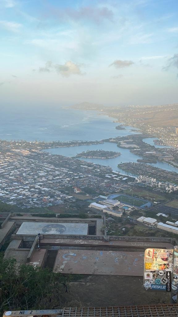
Hawaii Kai is a marina community built around a former fishpond on Oahu’s southeast shore, about 14 miles from downtown Honolulu. Mornings here start on the water: boats leaving the marina, paddleboards on the canals, and the Koko Head stairs before the sun gets high. It is a residential neighborhood first, and the bay, the crater, and the marina are part of the daily routine.
Where is Hawaii Kai, and what is the marina?
Hawaii Kai sits on Maunalua Bay, at the eastern end of the island. It is the largest of several communities at the eastern end of Oahu, and it is built around the marina.
The marina was once Kuapa Pond, a 523-acre fishpond and the largest on Oahu. In 1961, the Bernice Pauahi Bishop Estate leased the pond and the surrounding land to industrialist Henry J. Kaiser to develop. Over the next 20 years, Kaiser Development drained the pond, built miles of rock walls, and created the land for homes, shops, and roads. Dredging deepened the channels from two feet to six feet so boats could use them.
The result is the state’s only major marina residential development: nearly 13 miles of waterfront property lined with rock walls, with houses, townhomes, and shops arranged along canals and fingers of land. In 1979, the U.S. Supreme Court designated the marina as private property for the exclusive use of Hawaii Kai residents. In 1991, ownership passed to the Hawaii Kai Marina Community Association, which manages it today.
Hawaii Kai was the first master-planned community in Hawaii. The neighborhoods now extend back into the valleys and up the ridges behind the marina: Portlock at the oceanfront end, Kalama Valley toward Sandy Beach, Kuliouou to the west, and Mariners Ridge, Queen’s Gate, Hahaione, Kamiloiki, and Koko Kai in between. Townhome enclaves sit right on the water in several of these areas, some with dock or waterway access.
What does a marina morning look like?
The water sets the schedule. Boats leave through the channel to Maunalua Bay while the wind is still down. Paddleboarders and kayakers use the canals before the boat traffic picks up. People walk dogs along the waterfront paths, and the herons work the shallow edges.
The marina is tidal water, and it is private. The 1979 Supreme Court decision means the water is for Hawaii Kai residents, not a public boat harbor. That is part of what you are buying into here: water access that belongs to the neighborhood. If you are looking at a home in Hawaii Kai, ask what water access comes with it. Some homes have a dock. Some have a view of the water. Some are up the ridge with no water access at all, and they trade at a different price for that reason.
The shopping follows the same pattern. Koko Marina Center is the waterside shopping center Kaiser built during the development, and there are shopping centers in Kalama Valley and along Kalanianaole Highway. Groceries, coffee, and errands happen inside the neighborhood. Downtown is 14 miles away, and Kalanianaole Highway is the main road in and out.
What is Hanauma Bay, and how does it work for residents?
Hanauma Bay is the flooded volcanic crater just east of Hawaii Kai, and it is a Nature Preserve and a Marine Life Conservation District. For residents, it is a neighborhood beach with rules.
The preserve is open Wednesday through Sunday, with entry from 6:45 a.m. to 1:30 p.m., and everyone must be out by 4:00 p.m. It is closed every Monday and Tuesday, plus Christmas Day and New Year’s Day. Those two closed days give the reef a regular rest.
Non-residents pay $25 per person ages 13 and over, plus a small online service fee, and they need a reservation. Reservations open online two days before the visit at 7:00 a.m. Hawaii time through the City and County of Honolulu system. Hawaii residents with ID and active-duty military with ID enter free and do not need the online reservation. Every visitor watches the marine conservation video before entering.
For someone living in Hawaii Kai, the practical rules are simple. Plan a bay morning for Wednesday through Sunday. Go early, before the parking fills and the sun gets high. The reef is shallow in places, so float rather than stand on it. And check the city’s Hanauma Bay page before you go, because hours and closures change.
What is the Koko Head stairs climb?
The other morning ritual is the Koko Head stairs. The Koko Crater Railway Trail climbs the crater on 1,048 old railroad ties, about 1.6 miles round trip, gaining roughly 1,000 feet. The trailhead sits at Koko Head District Park, behind the ball fields in Hawaii Kai. It is free, with no permit system.
The steps were never built for hikers. During World War II, the U.S. Army built a cable tramway up the crater in 1942 and 1943 to carry people and supplies to a radar station on the summit. The rails are long gone. The wooden ties remain, and they are the staircase. The crater’s Hawaiian name is Kohelepelepe.
There is no shade and no water on the trail, so the climb happens early. The summit looks out over Hanauma Bay, Hawaii Kai, and the Pacific. Most people take 30 to 60 minutes to reach the top. It is a hard climb, and the locals who do it every morning make it look easy. It is not.
What are the neighborhoods inside Hawaii Kai?
Hawaii Kai is not one neighborhood. It is a set of valleys and ridges, each with its own feel.
Portlock is the oceanfront end, looking across Maunalua Bay toward Diamond Head. Kalama Valley sits toward the Sandy Beach end, with single-family subdivisions and a shopping center. Kuliouou is the western edge, closest to town. Mariners Ridge and Queen’s Gate run up the hillsides. Hahaione, Kamiloiki, and Koko Kai fill the valleys between them.
The waterfront homes and townhomes sit at the top of the market. The homes up the valleys and ridges trade lower per square foot. That spread is the point for a buyer: the same zip code covers marina-front living and hillside living, and the price difference between them is large. Walk the specific street before you decide what the neighborhood means to you.
What should a buyer know about living here?
Three checks matter more in Hawaii Kai than in most Oahu neighborhoods.
First, water access. Ask what comes with the home: a dock, a slip, marina rights, or none of those. The marina is private, so access is a property question, not a public one.
Second, flooding. Hawaii Kai is low-lying marina land. FEMA updated the Oahu flood maps on June 10, 2026. Check the map for the home and ask your insurer what it means for the premium before you offer.
Third, the commute. Kalanianaole Highway is the main road in and out, and downtown Honolulu is about 14 miles away. Drive it at the time you would actually drive it before you buy.
For islandwide context, the median Oahu single-family home sold for $1,150,000 in October 2026 and the median condo sold for $499,000 (Honolulu Board of REALTORS). The full October picture is in Oahu Market Update: October 2026. Hawaii Kai trades above those islandwide medians, and the spread between the waterfront and the ridges is wide, so use the islandwide numbers as background, not as a price for a specific street.
FAQ
Is Hawaii Kai on the ocean or on a marina?
Both. The community sits on Maunalua Bay, and it is built around the Hawaii Kai marina, a network of canals and waterways dredged from the former Kuapa Pond.
Can anyone use the Hawaii Kai marina?
No. The marina is private property for the exclusive use of Hawaii Kai residents, under a 1979 U.S. Supreme Court decision. It is managed by the Hawaii Kai Marina Community Association.
Is Hanauma Bay open every day?
No. The preserve is open Wednesday through Sunday and closed every Monday and Tuesday, plus Christmas Day and New Year’s Day. Entry runs 6:45 a.m. to 1:30 p.m.
How long is the Koko Head stairs hike?
The trail is 1,048 railroad ties, about 1.6 miles round trip, gaining roughly 1,000 feet. Most people take 30 to 60 minutes to reach the summit.
Book a free 30-minute call
Thinking about Hawaii Kai, or another corner of Oahu? Book a free 30-minute call and we will talk through what fits. Call or text (808) 450-0234, or email chris@pineapplehi.com.
Sources: Hawaii Kai Marina Community Association (hkpaoao.com) for marina history, 1961 Bishop Estate lease, 1979 Supreme Court decision, and 1991 ownership transfer. Images of Old Hawaii for Kuapa Pond history (523 acres, dredging from two to six feet). City and County of Honolulu Department of Parks and Recreation Hanauma Bay page, as reported in October 2026 guides (open Wednesday through Sunday, closed Monday and Tuesday, entry 6:45 a.m. to 1:30 p.m., $25 non-resident entry ages 13 and over, reservations two days ahead at 7:00 a.m. Hawaii time, residents and active-duty military free with ID). Koko Crater Railway Trail guides, October 2026 (1,048 ties, about 1.6 miles round trip, roughly 1,000 feet of gain, WWII tramway 1942-1943, trailhead at Koko Head District Park). Honolulu Board of REALTORS October 2026 Monthly Statistics Report, published November 6, 2026 (single-family median $1,150,000; condo median $499,000; resales only). FEMA Oahu flood maps, effective June 10, 2026.
By Chris Finateri, RA – Licensed Real Estate Salesperson, Talk Realty LLC, 2752 Woodlawn Dr Ste 5-202, Honolulu, HI 96822, (808) 450-0234. License RS-84267.
Figures verified November 10, 2026.